
The world of surveying has a long history. It has been around for thousands of years and it remains an important part of the world today.
The basic principles of land measurement are the same across the world. Measurements of the Earth’s surface are made with a variety of instruments and methods.
The Mason-Dixon Line
The Mason-Dixon Line was the result of numerous colonial and state boundary disputes. These included the disputes between the Calvert family in Maryland and William Penn of Pennsylvania.
They settled their disputes in 1732 with an agreement that specified specific borders for both territories. However, the lines still caused a lot of trouble between the two families.
After the surveyors were gone, the term “Mason-Dixon Line” became more commonly used to describe the boundary between states that allowed slavery and those that did not. This was especially true during the Civil War, when southern troops fought against northern troops.
The Mason-Dixon Line began to become a symbolic border between free and slave states, with the two British men who created it, Charles Mason and Jeremiah Dixon, becoming synonymous with this symbolism.
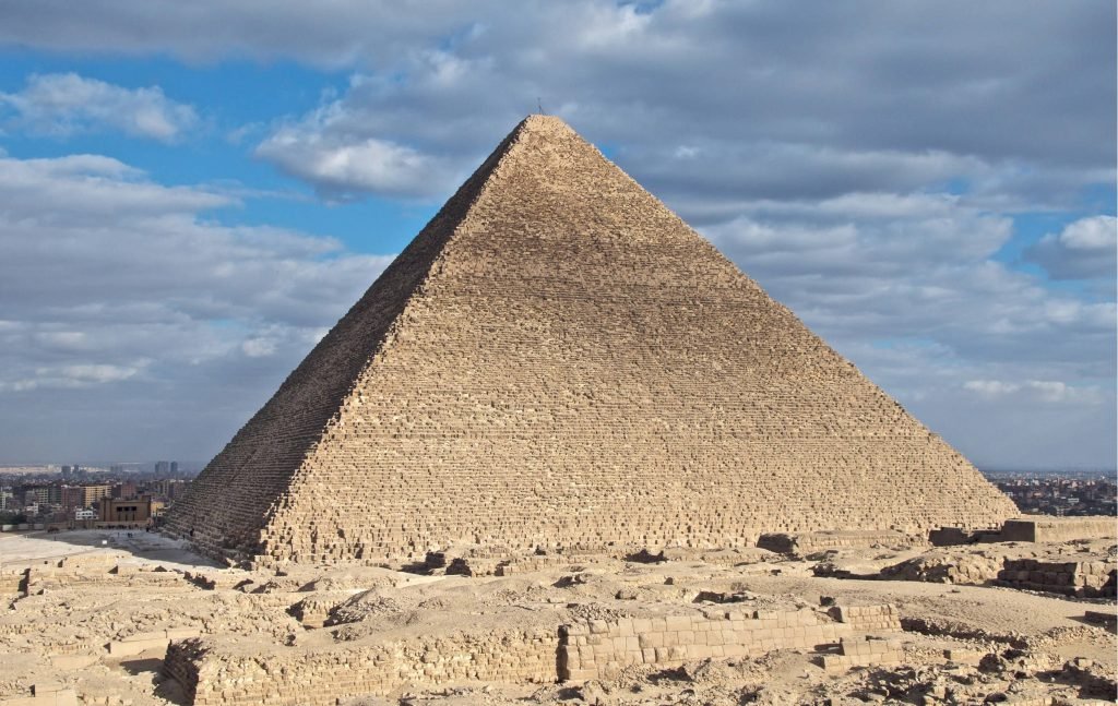
The Great Pyramid
Among the many great monuments of ancient Egypt, the Great Pyramid of Giza stands out as one of the most famous. The construction of the pyramid required an incredible amount of labor and resources.
This labor was done by a large number of skilled and unskilled workers. The annual inundation of the Nile River provided much-needed farmland that the kings could use to build their pyramids and other monuments.
Most of the pyramid stones in the Great Pyramid were transported from a quarry in Aswan, about 1000 km from Cairo. These were cut and fitted together with high precision.
The Great Wall of China
Stretching thousands of miles and featuring countless lookout towers, the Great Wall was an important military fortification to defend China against northern invaders. It has since become a symbol of Chinese history and culture, and is regarded as one of the world’s top tourist sights.
During the Qin Dynasty (221-207 BCE), Emperor Qin Shi Huang ordered that a strong wall be built to help keep out northern invaders like the Mongols. The wall was constructed of stone and earth and included watchtowers, beacon towers to send smoke signals and blockhouses to house soldiers.
After the Qin Dynasty, many different dynasties continued to work on the wall. It was reconstructed during the Ming Dynasty and eventually became the largest military structure in the world.
The Lewis and Clark Expedition
The Lewis and Clark Expedition (1804-1806) is a famous land surveying project that changed the course of American history. Meriwether Lewis and William Clark led the Corps of Discovery on an exploratory journey that ultimately reached the Pacific Ocean.
During the journey, they came across friendly Mandan and Minitari Indians who helped them build Fort Mandan along the Missouri River near present-day Washburn, North Dakota. The explorers were then able to obtain information from the Indians and French-Canadian traders who lived nearby.
While the explorers made their way up the Missouri River, they stopped at a spring where they observed “immense herds of Buffaloe, Elk, deer & Antelopes feeding in one common and boundless pasture.” The river became more difficult to navigate.
George Washington Smyth
Land surveyors have played an important role in our history. In fact, several famous historical figures were land surveyors.
George Washington, the first president of the United States, began his surveying career in 1749 at the age of 17. In a career that lasted over 50 years, he surveyed over 200 plots of land and played a vital role in western expansion.
During the colonial era, European powers needed detailed maps to back up their land claims in the new world. This led to the development of more advanced surveying techniques.

